
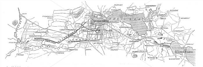
The Dannewerk, Kur-Graben, and East Rampart - from a plan by Lieutenant-Colonel W. Dreyer, taken in 1860, 1864. By reference to the accompanying Map it will be observed that the East Rampart is so arranged as to drive any approaching troops onwards towards the great lake formed by the River Schley, which is here so broad and so well protected by forts that it would be idle for any army to attempt crossing the water at that point: while, at the narrower part by the Mysund there exists, on the opposite shore, the great Margrethen Wall, as it is termed, and at which the entire population of Denmark is said in the olden time to have laboured for three long years. Immediately below the bay on which the city of Schleswig is built the two great Selker lakes will be seen to extend, and on the other side of these there is the great Half-Circle Fortification...ready to rain bullets upon any troops that may be rash enough to land there. From "Illustrated London News", 1864.
| px | px | dpi | = | cm | x | cm | = | MB |
Details
Creative#:
TOP29737994
Source:
達志影像
Authorization Type:
RM
Release Information:
須由TPG 完整授權
Model Release:
Not Required
Property Release:
Not Required
Right to Privacy:
No
Same folder images:
 Loading