
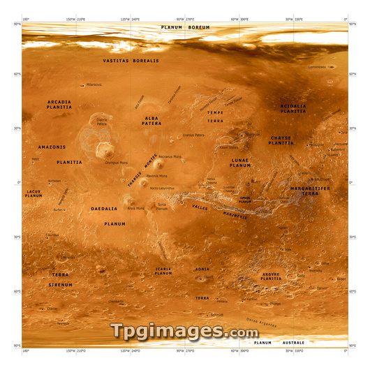
Mars topographical map. Three-dimensional composite satellite image of the surface of Mars. Topographical features are labelled in black. North is at top. Features visible include the Chryse Planitia (centre right), a plain with a diameter of around 840 kilometres, and Olympus Mons (centre left), the tallest known volcano and mountain in our solar system. The map was created using data from the Mars Global Surveyor spacecraft's Mars Orbiter Laser Altimeter.
| px | px | dpi | = | cm | x | cm | = | MB |
Details
Creative#:
TOP03224297
Source:
達志影像
Authorization Type:
RM
Release Information:
須由TPG 完整授權
Model Release:
N/A
Property Release:
N/A
Right to Privacy:
No
Same folder images:
CHRYSEPLANITIAOLYMPUSMONSMARSVOLCANOPLAINMAPPLANETSPACESOLARSYSTEMASTROPHYSICSASTRONOMYPLANETARYSCIENCESATELLITEIMAGECOMPOSITEMARSORBITERLASERALTIMETERMARSGLOBALSURVEYORBROWNASTRONOMICALASTROPHYSICALPLANETARYTOPOGRAPHYMAPPEDSPACECRAFTSURFACEMARTIANFEATUREFEATURESREGIONREGIONSCRATERCRATERSPLAINS3D3-D3DTHREEDIMENSIONALTHREE-DIMENSIONAL3-DIMENSIONAL3DIMENSIONALVOLCANOESTOPOGRAPHICMOLAMGSFROMSPACELABELLEDTOPOGRAPHICALTALLEST
333-D3-DIMENSIONAL3DALTIMETERASTRONOMICALASTRONOMYASTROPHYSICALASTROPHYSICSBROWNCHRYSECOMPOSITECRATERCRATERSDDIMENSIONALDIMENSIONALFEATUREFEATURESFROMGLOBALIMAGELABELLEDLASERMAPMAPPEDMARSMARSMARSMARTIANMGSMOLAMONSOLYMPUSORBITERPLAINPLAINSPLANETPLANETARYPLANETARYPLANITIAREGIONREGIONSSATELLITESCIENCESOLARSPACESPACESPACECRAFTSURFACESURVEYORSYSTEMTALLESTTHREETHREE-DIMENSIONALTOPOGRAPHICTOPOGRAPHICALTOPOGRAPHYVOLCANOVOLCANOES
 Loading