
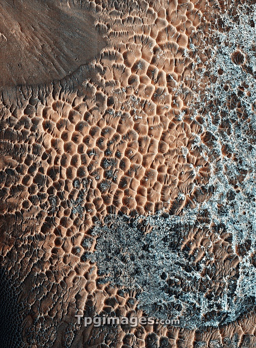
Martian central-peak crater floor, coloured satellite image. Central-peak craters form when the force of an impact causes the initial crater walls to collapse and produce a central uplift, or peak. The image shows the sand-covered surface on top of the central peak. The surface is pitted due to erosion. Image obtained by the High Resolution Imaging Science Experiment (HiRISE) camera on NASA's Mars Reconnaissance Orbiter (MRO) on 25th March 2009. The width of this image is roughly 1.2 kilometres across.
| px | px | dpi | = | cm | x | cm | = | MB |
Details
Creative#:
TOP06660719
Source:
達志影像
Authorization Type:
RM
Release Information:
須由TPG 完整授權
Model Release:
NO
Property Release:
NO
Right to Privacy:
No
Same folder images:
cratersandrockcentral-peakcratersolarsystemmarsgeographygeologyplanetarysciencesatelliteimagefromspacemarsreconnaissanceorbiterhirisecamera21stcentury2009centralpeakcentralpeakcratercraterfloorcraterformationerodederosiongeographicalgeologicalhighresolutionimaginghiriseimpactimpactcratermartianmronasapeakpitpitspittedplanetarysurfacespacemissionsurface"
"200921stcameracentralcentralcentral-peakcenturycratercratercratercratercratercratererodederosionfloorformationfromgeographicalgeographygeologicalgeologyhighhirisehiriseimageimagingimpactimpactmarsmarsmartianmissionmronasaorbiterpeakpeakpeakpitpitspittedplanetaryplanetaryreconnaissanceresolutionrocksandsatellitesciencesolarspacespacesurfacesurfacesystem
 Loading