
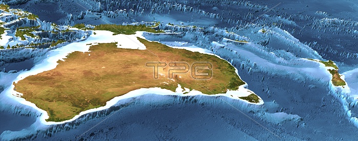
Australia and New Zealand. 3D computer graphic map of Australia and New Zealand, and the surrounding sea floor in the Pacific and Southern oceans. Image based on cloud-free satellite imagery, digital terrain and bathymetry data. The land is shown in natural colour, based on a cloud-free composite of thousands of weather satellite images, but with height-exaggerated terrain and highlighted rivers and lakes. The sea is shown coloured by depth from white for the shallow continental shelves, to dark blue for the deep ocean trenches.
| px | px | dpi | = | cm | x | cm | = | MB |
Details
Creative#:
TOP10705212
Source:
達志影像
Authorization Type:
RM
Release Information:
須由TPG 完整授權
Model Release:
No
Property Release:
No
Right to Privacy:
No
Same folder images:
PANORAMICPANORAMAENVIRONMENTGEOLOGYGEOLOGICALGEOGRAPHYGEOGRAPHICALPHYSICALGEOGRAPHYSIMULATEDSIMULATIONMODELARTWORKSATELLITEDIGITALTERRAINDATAMOUNTAINMOUNTAINSMOUNTAINOUSPEAKPEAKSCOASTCOASTALWATERBATHYMETRYBATHYMETRICCLOUD-FREECLOUDLESSCOMPOSITEIMAGEWEATHERSATELLITESEADEPTHDEPTHSHEIGHTHEIGHTSTOPOGRAPHYTOPOGRAPHICALMAPCARTOGRAPHYSEAFLOORCONTINENTALSHELFSHELVESPACIFICOCEANSOUTHERNOCEANNEWZEALANDOCEANIAAUSTRALIAPAPUANEWGUINEA3DTHREE-DIMENSIONAL3-DIMENSIONALSATELLITEIMAGEFROMSPACE
3-DIMENSIONAL3DARTWORKAUSTRALIABATHYMETRICBATHYMETRYCARTOGRAPHYCLOUD-FREECLOUDLESSCOASTCOASTALCOMPOSITECONTINENTALDATADEPTHDEPTHSDIGITALENVIRONMENTFLOORFROMGEOGRAPHICALGEOGRAPHYGEOGRAPHYGEOLOGICALGEOLOGYGUINEAHEIGHTHEIGHTSIMAGEIMAGEMAPMODELMOUNTAINMOUNTAINOUSMOUNTAINSNEWNEWOCEANOCEANOCEANIAPACIFICPANORAMAPANORAMICPAPUAPEAKPEAKSPHYSICALSATELLITESATELLITESATELLITESEASEASHELFSHELVESSIMULATEDSIMULATIONSOUTHERNSPACETERRAINTHREE-DIMENSIONALTOPOGRAPHICALTOPOGRAPHYWATERWEATHERZEALAND
 Loading