
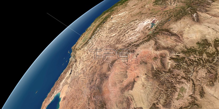
US South West. Simulated panoramic satellite image of the southwestern United States taken from low Earth orbit. Image created using a cloud-free mosaic of satellite images of the Earth's surface. Major physical features visible on the ground include the Rocky Mountains, the Great Salt Lake, the Great Basin and the Grand Canyon. Beyond, the dry states of Arizona, Nevada and Utah lie the green mountains of the Sierra Nevada and California's Central Valley.
| px | px | dpi | = | cm | x | cm | = | MB |
Details
Creative#:
TOP10705215
Source:
達志影像
Authorization Type:
RM
Release Information:
須由TPG 完整授權
Model Release:
No
Property Release:
No
Right to Privacy:
No
Same folder images:
PANORAMICPANORAMAENVIRONMENTGEOGRAPHYGEOGRAPHICALPHYSICALGEOGRAPHYSIMULATEDSIMULATIONMODELARTWORKSATELLITEIMAGEFROMSPACELOWEARTHORBITCOASTCOASTALUSUNITEDSTATESUSANORTHAMERICASOUTHERNSTATESSTATECURVATUREEARTHBLACKBACKGROUNDSOUTHWESTSOUTHWESTLOWEARTHORBITMOSAICROCKYMOUNTAINSGREATSALTLAKEGREATBASINGRANDCANYONARIZONANEVADAUTAHGREENMOUNTAINSSIERRANEVADACALIFORNIACENTRALVALLEYCLOUD-FREECLOUDLESS
AMERICAARIZONAARTWORKBACKGROUNDBASINBLACKCALIFORNIACANYONCENTRALCLOUD-FREECLOUDLESSCOASTCOASTALCURVATUREEARTHEARTHEARTHENVIRONMENTFROMGEOGRAPHICALGEOGRAPHYGEOGRAPHYGRANDGREATGREATGREENIMAGELAKELOWLOWMODELMOSAICMOUNTAINSMOUNTAINSNEVADANEVADANORTHORBITORBITPANORAMAPANORAMICPHYSICALROCKYSALTSATELLITESIERRASIMULATEDSIMULATIONSOUTHSOUTHERNSOUTHWESTSPACESTATESTATESSTATESUNITEDUSUSAUTAHVALLEYWEST
 Loading