
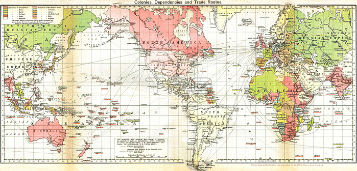
529503 Map of the British Empire, the areas controlled by Britain are shaded in pink. 19th century (map); Universal History Archive/UIG; out of copyright.
| px | px | dpi | = | cm | x | cm | = | MB |
Details
Creative#:
TOP27094733
Source:
達志影像
Authorization Type:
RM
Release Information:
須由TPG 完整授權
Model Release:
No
Property Release:
No
Right to Privacy:
No
Same folder images:
19thcentury19centuryXIXcenturyXIXthcenturyNineteenthCenturyc19th19XIXexixxixesi癡cle19nineteenthnineteenthnineteenthcenturyEnglandenglishGreatBritainbritishBritainGBunitedkingdomUKEuropeeuropeanmapcartographybritishhistorycontrolledareasshadedempirecenturypinkbritainbritishmap19thbritishhistorycontrolledareasshadedempirecenturypinkbritainbritishmap19th
19191919th19th19thBritainBritainCenturyEnglandEuropeGBGreatNineteenthUKXIXXIXeXIXthareasareasbritainbritainbritishbritishbritishbritishbritishc19thcartographycenturycenturycenturycenturycenturycenturycenturycontrolledcontrolledempireempireenglisheuropeanhistoryhistorykingdommapmapmapnineteenthnineteenthnineteenthpinkpinkshadedshadedsi癡cleunitedxixxixe
 Loading