
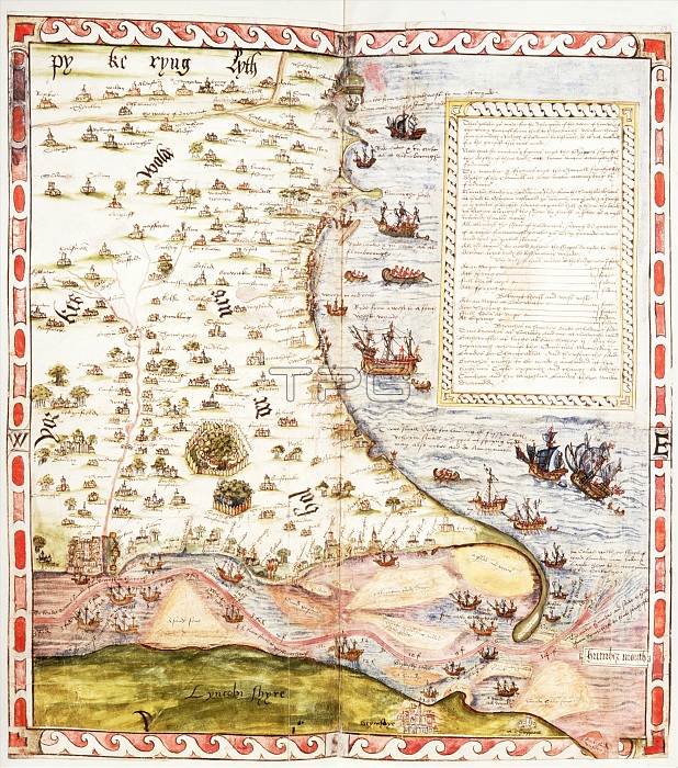
Map of the River Humber and land between Hull and Scarborough, 1579. Coloured manuscript plan of the River Humber and North Sea coast from Hull to Scarborough, with marginal notes by Lord Burghley. With particulars of the tides and a list of havens and Crickes on ye Northsyde of Humbre, pertening to ye Custom howse of Hull. From Lord Burghleys Atlas.
| px | px | dpi | = | cm | x | cm | = | MB |
Details
Creative#:
TOP30236952
Source:
達志影像
Authorization Type:
RM
Release Information:
須由TPG 完整授權
Model Release:
Not Required
Property Release:
Not Required
Right to Privacy:
No
Same folder images:
transporttransportationrivercoastEnglandlibrarycoastalcountrycoastlinefinanceshipshipsgeographyEnglishcolorLincolnshiremedievallocationcenturycartographyNorthSeanavigationHullBritishLibraryColourwatertransportmediaevalMiddleAges16thcenturyCustomHousesixteenthcenturyHumbersideEastRidingofYorkshiregeographicalfeaturemap-makingRiverHumberTGNMapmakingChristopherSaxtonSirWilliamCecilBurghleyCecilWilliamCecilBurghleyLordBurghleyWilliamCecilLordSaxtonChristopherSirWilliam1stBaronBurghley1stBaronBurleighHeritageArt
16th1st1stAgesArtBaronBaronBritishBurghleyBurghleyBurghleyBurghleyBurleighCecilCecilCecilCecilChristopherChristopherColourCustomEastEnglandEnglishHeritageHouseHullHumberHumbersideLibraryLincolnshireLordLordMapmakingMiddleNorthRidingRiverSaxtonSaxtonSeaSirSirTGNWilliamWilliamWilliamWilliamYorkshirecartographycenturycenturycenturycoastcoastalcoastlinecolorcountryfeaturefinancegeographicalgeographylibrarylocationmap-makingmediaevalmedievalnavigationofrivershipshipssixteenthtransporttransporttransportationwater
 Loading