
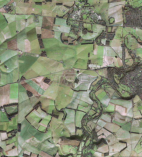
Stonehenge, UK, and surroundings in 2013, satellite image. Stonehenge, a circle of standing stones on Salisbury Plain, is just above and left of centre, surrounded by fields, roads and towns. At right is the town of Amesbury, UK. Some of the stones were erected around 2000 BC by a Stone Age civilisation known as the Beaker culture. At upper centre is a structure known as the Stonehenge Cursus, an ancient pathway 3 kilometres long and around 100 to 150 metres wide. Image obtained by a Pleiades satellite on 19 December 2013.
| px | px | dpi | = | cm | x | cm | = | MB |
Details
Creative#:
TOP25529389
Source:
達志影像
Authorization Type:
RM
Release Information:
須由TPG 完整授權
Model Release:
N/A
Property Release:
N/A
Right to Privacy:
No
Same folder images:
AMESBURYANCIENTARCHAEOLOGICALARCHEOLOGYBRITISHCIRCULARDURRINGTONENGLISHEUROPEANFROMSPACEGEOGRAPHICALHISTORICALLARKHILLNO-ONENOBODYPATHWAYPREHISTORICROUNDUNITEDKINGDOMSTONECIRCLETOURISTATTRACTIONEUROPEWILTSHIREENGLANDBRITAINUKGEOGRAPHYEARTHOBSERVATIONHISTORYARCHAEOLOGYSATELLITEIMAGESATELLITEPLEIADES21STCENTURYPREHISTORY201319DECEMBER2013STONEAGE
192013201321STAGEAMESBURYANCIENTARCHAEOLOGICALARCHAEOLOGYARCHEOLOGYATTRACTIONEUROPEBRITAINBRITISHCENTURYCIRCLECIRCULARDECEMBERDURRINGTONEARTHENGLANDENGLISHEUROPEANFROMGEOGRAPHICALGEOGRAPHYHISTORICALHISTORYIMAGEKINGDOMLARKHILLNO-ONENOBODYOBSERVATIONPATHWAYPLEIADESPREHISTORICPREHISTORYROUNDSATELLITESATELLITESPACESTONESTONETOURISTUKUNITEDWILTSHIRE
 Loading