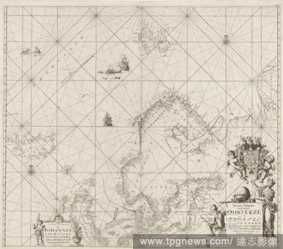
EditorialPassport of the Baltic Sea and the North Sea New Passport of the entire Oosterz? and Noortz?, Schip-Vaart, Op Nieuws uyt experience of Schrandre Stiermans Naaakeurig: Signed, and Saamen erected. (title on object), Passport card of the Baltic Sea and th...
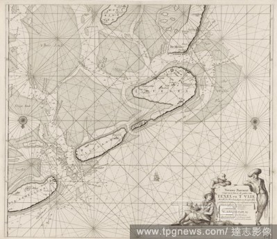
EditorialPassport map of the Wadden Sea from Den Helder to Terschelling New Pascaert Where to insert the holes of Texel and 'T Vlie With all syn Mercken and, depth and drought everything on 't Nieuws Oversien and corrected of many errors (title on object), Pass...
EditorialPass card of a part of the coast of Ireland, England, France and Spain Pass card of the Bight of Vrankryck Biscaien and Galissen the income of the Canaal as Meden 't Channel of Bristol and the Zuyd coast of Yrland (title on object), Passport card of a ...
EditorialMap of Palestine Terrae Sanctae seu terrae promissionis nova descripto (title on object), Upper right plate of a map of Palestine, with inscriptions relating to the events of the Old and New Testament. At the top a smaller map of Egypt. Four performanc...
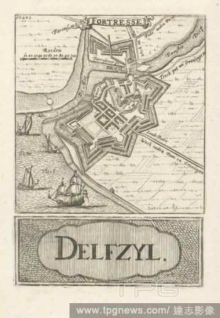
EditorialMap of Delfzijl Fortresse Delfzyl (title on object), Two prints on one sheet: At the top a print with a representation of a map of Delfzijl and below a print with the title in a cartouche. In the top print a part of the title on top of a ribbon, a scal...
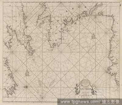
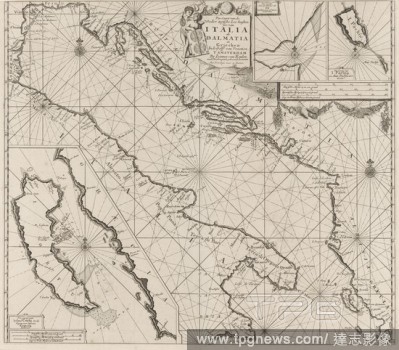
EditorialMap of the coasts of the Adriatic Sea Pas-Caart of the Weder zytsche Sea coasts of Soo from Italia as Dalmatia and Griecken In the Golff of Venetien (title on object), Map from the coasts of the Adriatic Sea, three betting cards, bottom left one from C...
EditorialMap of Palestine of Palestine, with inscriptions relating to the events of the Old and New Testament., maps, atlases, Palestine, Israel, Nicolaes van Geelkercken, Amsterdam, 1621, paper, engraving, w 420 mm ? h 550 mm.
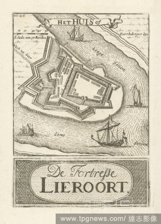
EditorialMap of the Lierort fortress Het Huis or De Fortresse Lieroort (title on object), Two prints on one sheet: At the top a print with a representation of the Lierort fortress and below a print with the title in it a cartouche. In the top print a part of th...
EditorialPassport map of the Zuiderzee and the Wadden Sea Passport map of the Zuyder Zee (title on object), Passport map of the Zuiderzee and the Wadden Sea, with all sandbanks and depths. With the Wadden Islands (with the exception of Schiermonnikoog) and a la...
EditorialPortrait of an unknown man The person portrayed stands in a room with a hand on his hip and leans on an office chair. A map and prints hang on the wall. On the desk next to him are paper and writing materials., Anonymous historical person portrayed, wr...
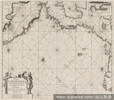
EditorialPassport card from the coasts of Colombia, Panama, Costa Rica and Honduras, with an insert card from Carthagena Pass card from the sea coasts of Carthagena Tierra Company, Costa Rica and Honduras. between Rio Grande de S. Martha and Cabo de Gratias Dio...
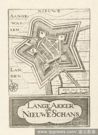
EditorialMap of Nieuweschans Lange Akker of the Nieuwe Schans (title on object), Two prints on one sheet: At the top a print with a representation of a map of Nieuweschans and below a print with the title in a cartouche. In the upper print at the bottom right a...
EditorialPassport card from a part of the north east coast of Scotland and the Orkney Islands New Pascaert from the East Cust of Scotlandt Starting from Barwyck to the Orcades Ylanden (title on object) part of the north east coast of Scotland and the Orkney Isl...
EditorialEurope. Collins' Series of Atlases. The Student's Atlas of. London, Glasgow and Edinburgh : William Collins, S. Source: Maps.49.c.78, no.13. Language: English.
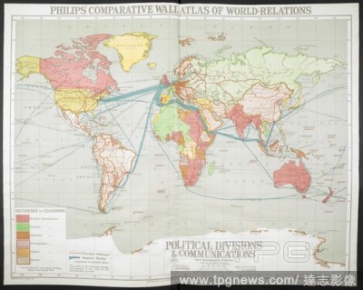
EditorialA map of the world . Philips' Comparative Series of Wall Atlases. World relations. Relief of Land. (Political Divisions & Communications. Climate, May 1--Oct. 31. Climate Nov. 1--April 30. Temperature. Annual Rainfall and Range of Temperature with July...
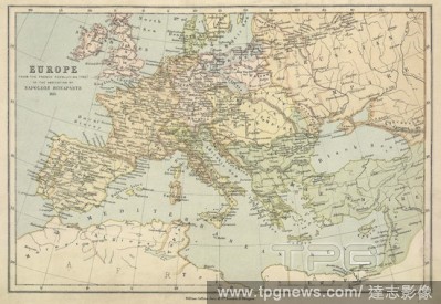
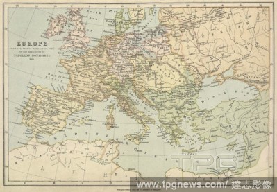
EditorialA map of Europe from the French Revolution (1793) to the abdication of Napoleon Bonaparte 1815. Collins' Series of Atlases. The Student's Atlas of Historical Geography, consisting of sixteen Maps, constructed and engraved by Edward Weller, F.R.G.S., an...
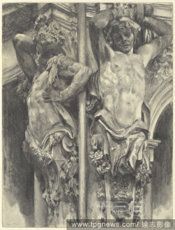
EditorialAtlases on the Wallpavillon of the Dresden Zwinger. Dated: 1880. Dimensions: sheet: 32.3 x 24.4 cm (12 11/16 x 9 5/8 in.). Medium: graphite with stumping, on wove paper with a ribbed or laid pattern.
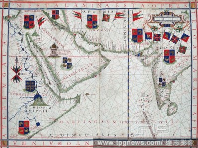
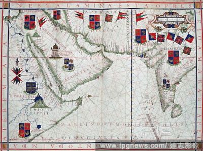
EditorialMap of the Middle East, 1575. A Potuguese map with coats of arms, showing what is now Iran, Saudi Arabia, Yemen, the Horn of Africa, Egypt and the river Nile. Fernao Vaz Dourrado who produced this map, was Portuguese who sepnt much of his life in Ind...
EditorialAtlases on the Wallpavillon of the Dresden Zwinger. Dated: 1880. Dimensions: sheet: 32.3 x 24.4 cm (12 11/16 x 9 5/8 in.). Medium: graphite with stumping, on wove paper with a ribbed or laid pattern.
EditorialMap of the Middle East, 1575. A Potuguese map with coats of arms, showing what is now Iran, Saudi Arabia, Yemen, the Horn of Africa, Egypt and the river Nile. Fernao Vaz Dourrado who produced this map, was Portuguese who sepnt much of his life in Ind...


 Loading