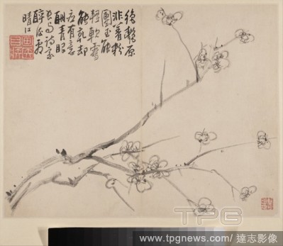
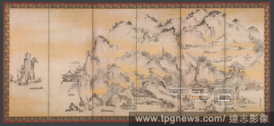
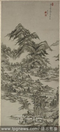
EditorialLandscape after Huang Gongwang. Wang Yuanqi; Chinese, from Taicang, Jiangsu province, 1642-1715. Date: 1701. Dimensions: . Hanging scroll; ink and color on paper; with box. Origin: China.
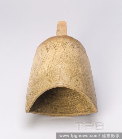
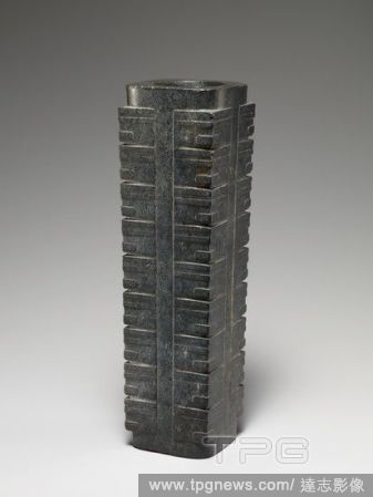
EditorialModel of a Bell (Goudiao). China, probably Zhejiang or Jiangsu province. Date: 480 BC-221 BC. Dimensions: 23.6 ? 12.5 cm. Buff stoneware with incised decoration. Origin: China.
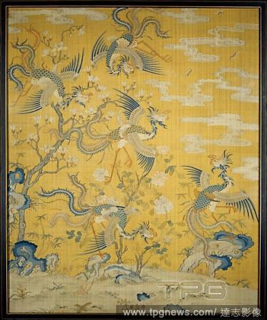
EditorialPanel with Phoenixes in a Garden, Qing dynasty (1644?1911), Kangxi period (1662?1722), late 17th?early 18th century, China, Silk with metallic thread tapestry (kesi) with painted details, Overall: 118 1/2 x 82 in. (301 x 208.3 cm), Textiles-Tapestries,...
EditorialLandscape after Huang Gongwang. Wang Yuanqi; Chinese, from Taicang, Jiangsu province, 1642-1715. Date: 1701. Dimensions: . Hanging scroll; ink and color on paper; with box. Origin: China.
EditorialLandscape after Huang Gongwang. Wang Yuanqi; Chinese, from Taicang, Jiangsu province, 1642-1715. Date: 1701. Dimensions: . Hanging scroll; ink and color on paper; with box. Origin: China.
EditorialLandscape after Huang Gongwang. Wang Yuanqi; Chinese, from Taicang, Jiangsu province, 1642-1715. Date: 1701. Dimensions: . Hanging scroll; ink and color on paper; with box. Origin: China.
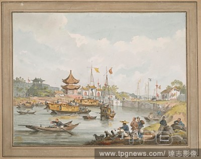
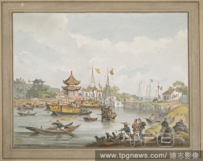
EditorialChinese military drawn out to salute the Ambassador on passing up the Grand Canal in Jiangsu. . A collection of eighty views, maps, portraits and drawings illustrative of the Embassy sent to China under George, Earl of Macartney, in 1793; drawn chiefly...
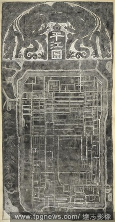
EditorialChinese town plan. Plan of Suzhou, China. Rubbing. China, 1229. This rubbing of a map of Suzhou is taken from a stone engraved in 1229 AD. It is entitled Pingjiang tu. Pingjiang is an ancient name for Suzhou, a city in Jiangsu province, China. Source: ...
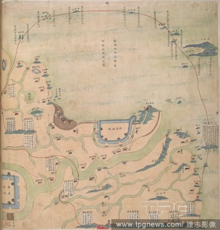
EditorialA Map of the salt-transport canals in Jiangsu Province, ca. 1830. . Sixteen Official Military Maps of China, viz. Embouchure of the Canton River, in Kwangtung; Nine maps of parts of the province of Chekeang; Six maps of parts of Keangsoo. China, ca.18...
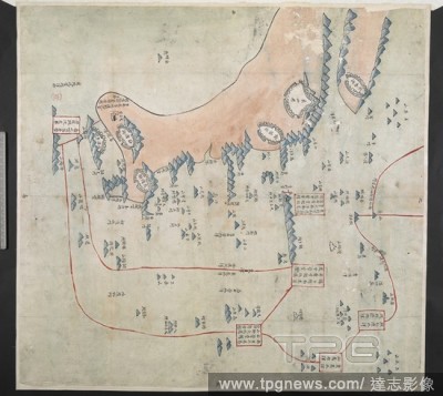
EditorialSheet from a manuscript atlas showing Canton and parts of Zhejiang and Jiangsu provinces. Red lines indicate defence boundaries. The area depicted in this sheet is Xiangshan Country, Ningbo Prefecture, Zhejiang. 16 Official native maps of China. Source...
EditorialChinese military drawn out to salute the Ambassador on passing up the Grand Canal in Jiangsu. . A collection of eighty views, maps, portraits and drawings illustrative of the Embassy sent to China under George, Earl of Macartney, in 1793; drawn chiefly...
EditorialPanel with Phoenixes in a Garden, Qing dynasty (1644?1911), Kangxi period (1662?1722), late 17th?early 18th century, China, Silk with metallic thread tapestry (kesi) with painted details, Overall: 118 1/2 x 82 in. (301 x 208.3 cm), Textiles-Tapestries,...
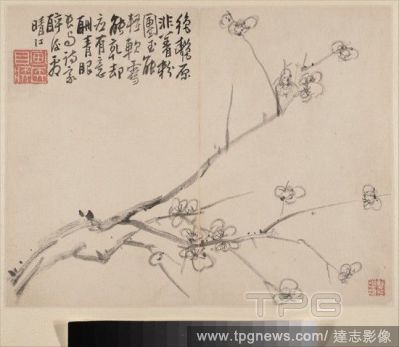
EditorialTeapot in the Shape of a Plum Blossom, Qing dynasty (1644?1911), early 17th century, China, Stoneware (Yixing ware), H. 3 3/4 in. (9.5 cm), Ceramics, Shi Dabin (Chinese, active 1620?40), The invention of the teapot is often credited to potters working ...
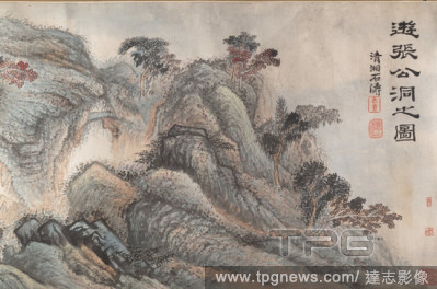
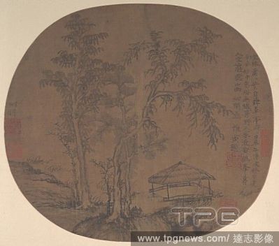
Editorial? ?? ????? ??, Sparse Trees and Pavilion, late Yuan dynasty (1271?1368), ca. 1361, China, Fan mounted as an album leaf; ink on silk, Image: 9 7/8 x 11 1/8 in. (25.1 x 28.3 cm), Paintings, Wang Meng (Chinese, ca. 1308?1385), Wang Meng painted and inscri...
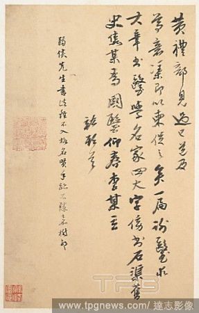
Editorial? ?? ???? ??, Letter, Ming dynasty (1368?1644), China, Album leaf; ink on paper, 10 5/8 x 6 5/8 in. (27 x 16.8 cm), Calligraphy, Jiao Hong (Chinese, 1541?1620), A native of Nanjing, Jiangsu Province, Jiao Hong was a prolific scholar, noted bibliophile,...


 Loading