
filter
-
Brand
- By Category
- Direction
- Date Range
198Events
Pictures
Events

Editorial
- 2023-12-07
- 1

Editorial
- 2023-12-07
- 1
Editorial
- 2023-11-01
- 1
Editorial
- 2023-11-01
- 1

Editorial
- 2023-11-01
- 1
Editorial
- 2023-11-01
- 1

Editorial
- 2023-11-01
- 1
Editorial
- 2023-11-01
- 1

Editorial
- 2023-11-01
- 1
Editorial
- 2023-11-01
- 1
Editorial
- 2023-11-01
- 1
Editorial
- 2023-11-01
- 1

Editorial
- 2023-11-01
- 1

Editorial
- 2023-11-01
- 1

Editorial
- 2023-11-01
- 1
Editorial
- 2023-11-01
- 1

Editorial
- 2023-11-01
- 1

Editorial
- 2023-11-01
- 13

Editorial
- 2023-11-01
- 2

Editorial
- 2023-11-01
- 26
Editorial
- 2023-11-01
- 4

Editorial
- 2023-06-15
- 1

Editorial
- 2023-06-15
- 1

Editorial
- 2023-06-15
- 1

Editorial
- 2023-06-14
- 1

Editorial
- 2023-06-07
- 1

Editorial
- 2023-06-07
- 2

Editorial
- 2023-06-07
- 1

Editorial
- 2023-06-07
- 1

Editorial
- 2023-06-07
- 1

Editorial
- 2023-06-07
- 1

Editorial
- 2023-06-07
- 1

Editorial
- 2023-06-07
- 1

Editorial
- 2023-06-07
- 1

Editorial
- 2023-06-07
- 1
Editorial
- 2023-06-07
- 1

Editorial
- 2023-06-07
- 1
Editorial
- 2023-06-07
- 1

Editorial
- 2023-06-07
- 1

Editorial
- 2023-06-07
- 1

Editorial
- 2023-06-07
- 1

Editorial
- 2023-06-07
- 1

Editorial
- 2023-06-07
- 1

Editorial
- 2023-06-07
- 1

Editorial
- 2023-06-07
- 1

Editorial
- 2023-06-07
- 1

Editorial
- 2023-06-07
- 1

Editorial
- 2023-06-07
- 1

Editorial
- 2023-06-07
- 1

Editorial
- 2023-06-07
- 1

Editorial
- 2023-06-07
- 1

Editorial
- 2023-06-07
- 1

Editorial
- 2023-06-07
- 1
Editorial
- 2023-06-07
- 1

Editorial
- 2023-06-07
- 2

Editorial
- 2023-06-07
- 1

Editorial
- 2023-06-07
- 1
Editorial
- 2023-06-07
- 1
Editorial
- 2023-06-07
- 1

Editorial
- 2023-03-17
- 1

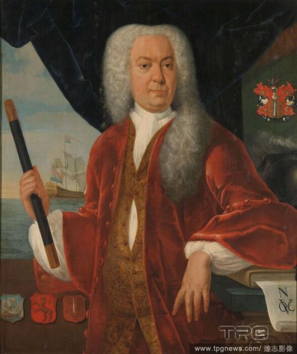
Editorial Isaac de l'Ostal de Saint-Martin (c 1629-96), Councillor of the Dutch East Indies and Commander of the Garrison at Batavia. Dating: 1650 - 1702. Measurements: h 132 cm ? w 102 cm; d 5 cm.
- 2022-12-25
- 1

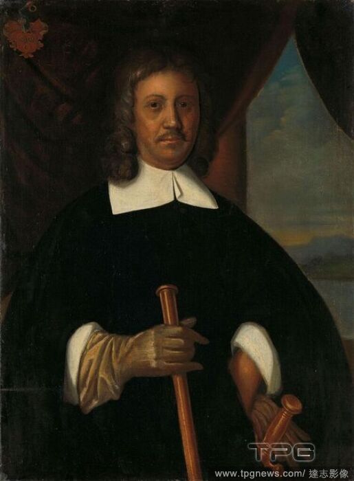
Editorial Portrait of Jan van Riebeeck (1619-77). Commander of the Cape of Good Hope and of Malacca and Secretary of the High Government of Batavia. Dating: c. 1660. Place: Northern Netherlands. Measurements: h 94 cm ? w 69 cm; d 10 cm.
- 2022-07-21
- 1
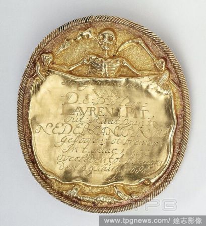
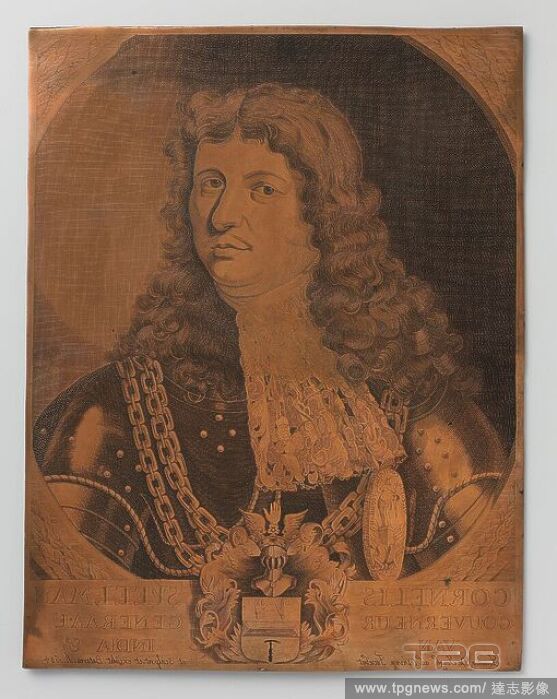
Editorial Funeral medal following the death of Laurens Pit, among others. governor of Coromandel from 1652 to 1663 and Council of India from 1662 to 1678, on June 29, 1684 in Batavia, cast gold oval medallion with cord edging, vz: skeleton facing the spectator h...
- 2022-07-21
- 1

Editorial Herman's Hermits with Peter Noone 2022 Tour
- 2022-07-18
- 2

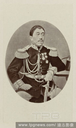
Editorial Johannes Benedictus van Heutsz (1851-1924). Governor General (1904-09). Dating: 1909. Place: Batavia. Measurements: h 141.5 cm ? w 101.08 cm ? t 4.0 cm; d 9.2 cm.
- 2022-04-24
- 1

Editorial MARK DAWSON performs during the Grass Roots tour
- 2022-02-06
- 1
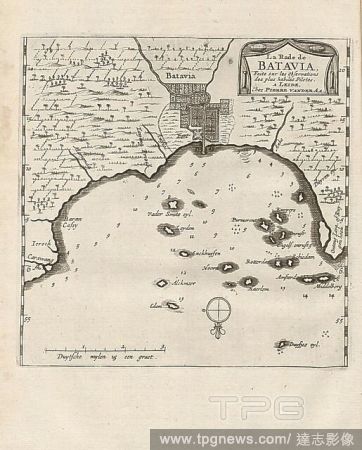
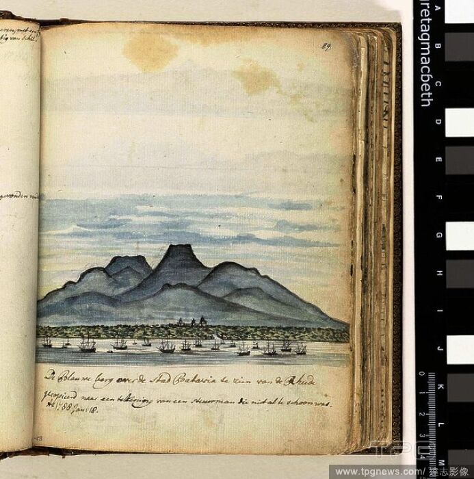
Editorial The Rata of Batavia, Map of the anchorage of Batavia from the 18th century, signed: Faite sur les Observations des plus habiles Pilotes., A LEIDE, Chez PIERRE VAN DER AA, Fig. 23, according to p. 392, Aa, Pierre van der (chez), 1727, Adam Olearius: Voy...
- 2022-01-18
- 1

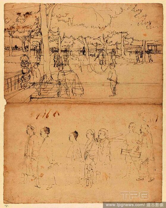
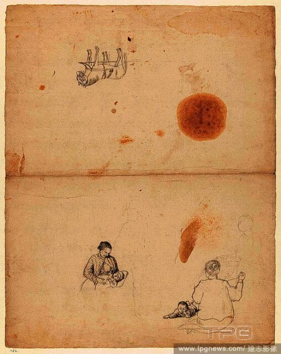
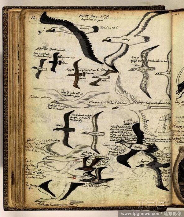
Editorial A page from the ship's journal / logbook of the 'Rochester'. In 1709 thr East India company ship the Rochester, sailed from England for China, via Batavia (now Jakarata). The ship's captain enlivened his journal with images of ships, wildlife and place...
- 2022-01-18
- 1

Editorial Edward Pellew,1st Viscount Exmouth, Admiral (1757-1835) c.1817 A full-length figure. Pellew is shown standing on his quarter-deck, during the bombardment of Algiers, bareheaded, a telescope in his right hand and the left raised. He wears the ribbon and...
- 2021-10-09
- 1

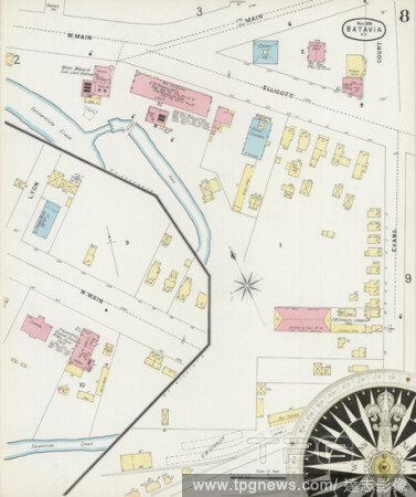
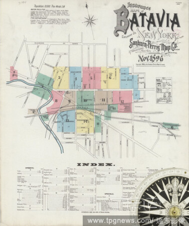
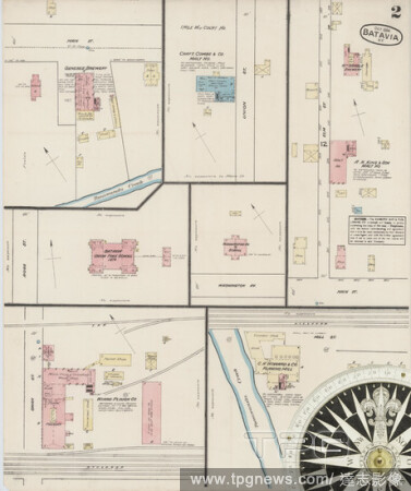
Editorial Image 2 of Sanborn Fire Insurance Map from Batavia, Genesee County, New York. Nov 1896. 15 Sheet(s), America, street map with a Nineteenth Century compass.
- 2021-02-20
- 1
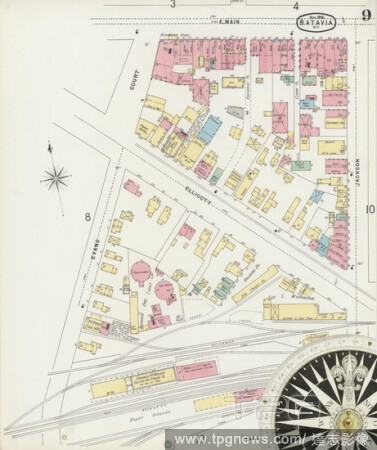
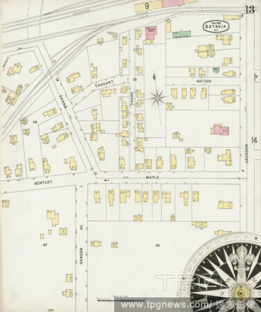
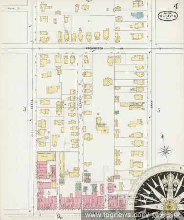
Editorial Image 9 of Sanborn Fire Insurance Map from Batavia, Genesee County, New York. Nov 1896. 15 Sheet(s), America, street map with a Nineteenth Century compass.
- 2021-02-20
- 1

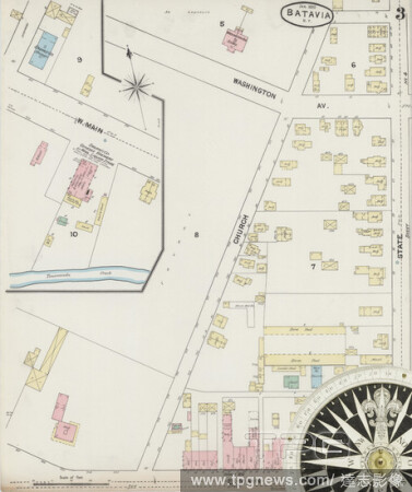
Editorial Image 1 of Sanborn Fire Insurance Map from Batavia, Genesee County, New York. Jan 1890. 11 Sheet(s), America, street map with a Nineteenth Century compass.
- 2021-02-20
- 1
Editorial Image 8 of Sanborn Fire Insurance Map from Batavia, Genesee County, New York. Nov 1896. 15 Sheet(s), America, street map with a Nineteenth Century compass.
- 2021-02-20
- 1
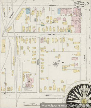
Editorial Image 14 of Sanborn Fire Insurance Map from Batavia, Genesee County, New York. Nov 1896. 15 Sheet(s), America, street map with a Nineteenth Century compass.
- 2021-02-20
- 1
Editorial Image 5 of Sanborn Fire Insurance Map from Batavia, Genesee County, New York. Jan 1890. 11 Sheet(s), America, street map with a Nineteenth Century compass.
- 2021-02-20
- 1
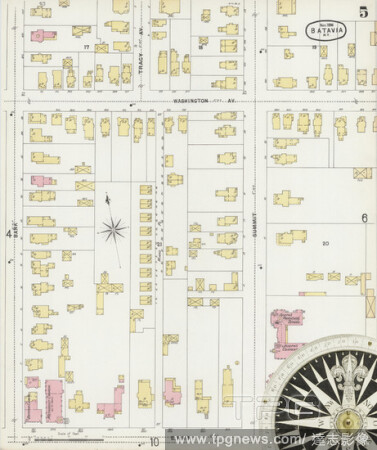
Editorial Image 13 of Sanborn Fire Insurance Map from Batavia, Genesee County, New York. Nov 1896. 15 Sheet(s), America, street map with a Nineteenth Century compass.
- 2021-02-20
- 1
Editorial Image 3 of Sanborn Fire Insurance Map from Batavia, Genesee County, New York. Jan 1890. 11 Sheet(s), America, street map with a Nineteenth Century compass.
- 2021-02-20
- 1

Editorial Image 2 of Sanborn Fire Insurance Map from Batavia, Genesee County, New York. Jan 1890. 11 Sheet(s), America, street map with a Nineteenth Century compass.
- 2021-02-20
- 2
Editorial Image 1 of Sanborn Fire Insurance Map from Batavia, Genesee County, New York. Oct 1884. 5 Sheet(s), America, street map with a Nineteenth Century compass.
- 2021-02-20
- 1

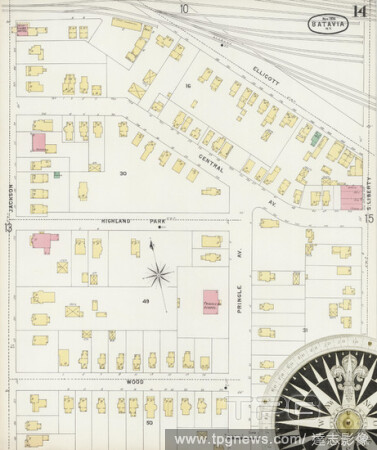
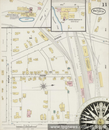
Editorial Image 10 of Sanborn Fire Insurance Map from Batavia, Genesee County, New York. Nov 1896. 15 Sheet(s), America, street map with a Nineteenth Century compass.
- 2021-02-20
- 2
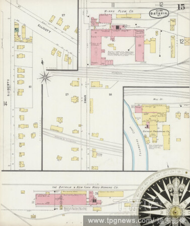
Editorial Image 15 of Sanborn Fire Insurance Map from Batavia, Genesee County, New York. Nov 1896. 15 Sheet(s), America, street map with a Nineteenth Century compass.
- 2021-02-20
- 1
Editorial Image 7 of Sanborn Fire Insurance Map from Batavia, Genesee County, New York. Jan 1890. 11 Sheet(s), America, street map with a Nineteenth Century compass.
- 2021-02-20
- 1

Editorial Image 6 of Sanborn Fire Insurance Map from Batavia, Genesee County, New York. Jan 1890. 11 Sheet(s), America, street map with a Nineteenth Century compass.
- 2021-02-19
- 2
Editorial Image 4 of Sanborn Fire Insurance Map from Batavia, Genesee County, New York. Oct 1884. 5 Sheet(s), America, street map with a Nineteenth Century compass.
- 2021-02-19
- 2
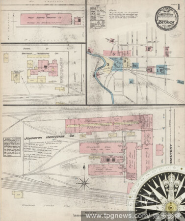
Editorial Image 1 of Sanborn Fire Insurance Map from Batavia, Genesee County, New York. Nov 1896. 15 Sheet(s), America, street map with a Nineteenth Century compass.
- 2021-02-19
- 2

Editorial Image 5 of Sanborn Fire Insurance Map from Batavia, Genesee County, New York. Oct 1884. 5 Sheet(s), America, street map with a Nineteenth Century compass.
- 2021-02-19
- 2
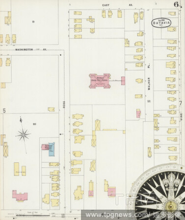
Editorial Image 6 of Sanborn Fire Insurance Map from Batavia, Genesee County, New York. Nov 1896. 15 Sheet(s), America, street map with a Nineteenth Century compass.
- 2021-02-19
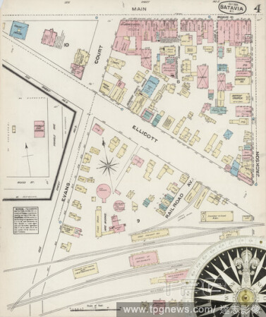
- 4

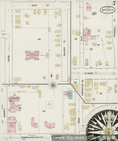
Editorial Image 7 of Sanborn Fire Insurance Map from Batavia, Genesee County, New York. Nov 1896. 15 Sheet(s), America, street map with a Nineteenth Century compass.
- 2021-02-19
- 2

Editorial Image 4 of Sanborn Fire Insurance Map from Batavia, Genesee County, New York. Jan 1890. 11 Sheet(s), America, street map with a Nineteenth Century compass.
- 2021-02-19
- 2

Editorial Image 12 of Sanborn Fire Insurance Map from Batavia, Genesee County, New York. Nov 1896. 15 Sheet(s), America, street map with a Nineteenth Century compass.
- 2021-02-19
- 2
Editorial Image 2 of Sanborn Fire Insurance Map from Batavia, Genesee County, New York. Oct 1884. 5 Sheet(s), America, street map with a Nineteenth Century compass.
- 2021-02-19
- 2

Editorial Image 3 of Sanborn Fire Insurance Map from Batavia, Genesee County, New York. Nov 1896. 15 Sheet(s), America, street map with a Nineteenth Century compass.
- 2021-02-19
- 2
Editorial Image 4 of Sanborn Fire Insurance Map from Batavia, Genesee County, New York. Nov 1896. 15 Sheet(s), America, street map with a Nineteenth Century compass.
- 2021-02-19
- 2

Editorial Image 10 of Sanborn Fire Insurance Map from Batavia, Genesee County, New York. Jan 1890. 11 Sheet(s), America, street map with a Nineteenth Century compass.
- 2021-02-19
- 2
Editorial Image 11 of Sanborn Fire Insurance Map from Batavia, Genesee County, New York. Jan 1890. 11 Sheet(s), America, street map with a Nineteenth Century compass.
- 2021-02-19
- 2

Editorial Image 9 of Sanborn Fire Insurance Map from Batavia, Genesee County, New York. Jan 1890. 11 Sheet(s), America, street map with a Nineteenth Century compass.
- 2021-02-19
- 2
Editorial Image 5 of Sanborn Fire Insurance Map from Batavia, Genesee County, New York. Nov 1896. 15 Sheet(s), America, street map with a Nineteenth Century compass.
- 2021-02-19
- 2

Editorial Goblet with lid, with the coat of arms of Batavia and the VOC monogram, Vaulted foot with folded edge Hollow baluster stem with a button. On the tulip-shaped chalice the VOC monogram in a shield between Neptune and mermaid, as well as the coat of arms ...
- 2020-12-04
- 1
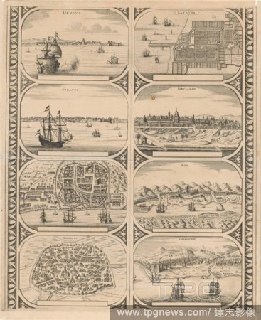
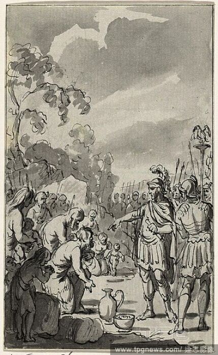
Editorial Ormovs / Svrattte / Bantam / Damasco / Batavia / Iervsalem / Goa / Calecvth (title on object), Sheet with two vertical strips each with four views of the cities in Asia: Hormoz, Suratte, Bantam, Damascus, Batavia, Jerusalem, Goa and Calcutta. Uncut lea...
- 2020-12-04
- 1
 Loading